Hydrogeology of Eritrea
Africa Groundwater Atlas >> Hydrogeology by country >> Hydrogeology of Eritrea
This page has limited information. If you have more information on the hydrogeology of Eritrea, please get in touch!

Many ancient civilisations inhabited the area of present-day Eritrea. In the 16th century parts of the country came under Ottoman governance, including the coastal zone until the period of Italian colonisation in the late 19th century. During Italian occupation, the country saw major development of the industrial, agricultural and public service sectors. In the 1930s Italian Eritrea was merged with Italian Somaliland and Ethiopia as Italian East Africa. In 1941 Britain took over administration of Eritrea, and in 1950 the country was federated to Ethiopia. Ethiopia entirely annexed Eritrea in 1962, which was followed by 30 years of the Eritrean War for Independence, finally ending in 1991 when Ethiopian forces were defeated. The winning Eritrean People's Liberation Front has held power ever since in a one-party state. No national elections have been held in Eritrea since independence. Another border war with Ethiopia happened between 1998 and 2000, since when there has been periodic further unrest. International observers cite Eritrea as having one of the worst human rights records globally.
Eritrea’s economy was severely affected by decades of war, with widespread loss of infrastructure and livestock. Recent growth in GDP is in part due to the development of mining (particularly of gold and silver) and other industry. The country has large mineral resources that are so far largely undeveloped. Most of the population are employed in subsistence agriculture, including livestock farming. However, migration from Eritrea is high, and combined with compulsory military service has reduced the agricultural workforce, affecting productivity and food security. Remittances from abroad are estimated to account for about one third of GDP.
Eritrea has limited water resources. Average annual rainfall is low and unevenly distributed both seasonally and spatially, and much rainfall occurs as high intensity events that cause flash flooding but do not sustain perennial river flows. Groundwater supplies most of the country’s water supply needs.
Compilers
Dr Kirsty Upton and Brighid Ó Dochartaigh, British Geological Survey, UK
Dr Imogen Bellwood-Howard, Institute of Development Studies, UK
Please cite this page as: Upton, Ó Dochartaigh and Bellwood-Howard, 2018.
Bibliographic reference: Upton K, Ó Dochartaigh BÉ and Bellwood-Howard, I. 2018. Africa Groundwater Atlas: Hydrogeology of Eritrea. British Geological Survey. Accessed [date you accessed the information]. http://earthwise.bgs.ac.uk/index.php/Hydrogeology_of_Eritrea
Terms and conditions
The Africa Groundwater Atlas is hosted by the British Geological Survey (BGS) and includes information from third party sources. Your use of information provided by this website is at your own risk. If reproducing diagrams that include third party information, please cite both the Africa Groundwater Atlas and the third party sources. Please see the Terms of use for more information.
Geographical Setting

General
| Capital city | Asmara |
| Region | Eastern Africa |
| Border countries | Sudan, Ethiopia, Djibouti |
| Total surface area* | 117,600 km2 (11,760,000 ha) |
| Total population (2015)* | 5,228,000 |
| Rural population (2015)* | 3,703,000 (71%) |
| Urban population (2015)* | 1,525,000 (29%) |
| UN Human Development Index (HDI) [highest = 1] (2014)* | 0.3909 |
* Source: FAO Aquastat
Climate
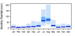
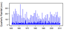
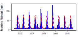
More information on average rainfall and temperature for each of the climate zones in Eritrea can be seen at the Eritrea climate page.
These maps and graphs were developed from the CRU TS 3.21 dataset produced by the Climatic Research Unit at the University of East Anglia, UK. For more information see the climate resource page.
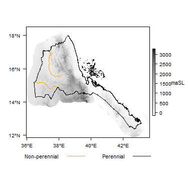
Surface water
|
|
 |
Soil
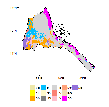 |
Land cover
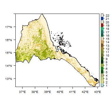 |
Water statistics
| 1993 | 2004 | 2014 | 2015 | |
| Rural population with access to safe drinking water (%) | 53.3 | |||
| Urban population with access to safe drinking water (%) | 73.2 | |||
| Population affected by water related disease | No data | No data | No data | No data |
| Total internal renewable water resources (cubic metres/inhabitant/year) | 535.6 | |||
| Total exploitable water resources (Million cubic metres/year) | No data | No data | No data | No data |
| Freshwater withdrawal as % of total renewable water resources | 7.956 | |||
| Total renewable groundwater (Million cubic metres/year) | 500 | |||
| Exploitable: Regular renewable groundwater (Million cubic metres/year) | No data | No data | No data | No data |
| Groundwater produced internally (Million cubic metres/year) | 500 | |||
| Fresh groundwater withdrawal (primary and secondary) (Million cubic metres/year) | No data | No data | No data | No data |
| Groundwater: entering the country (total) (Million cubic metres/year) | ||||
| Groundwater: leaving the country to other countries (total) (Million cubic metres/year) | ||||
| Industrial water withdrawal (all water sources) (Million cubic metres/year) | 1 | |||
| Municipal water withdrawal (all water sources) (Million cubic metres/year) | 31 | |||
| Agricultural water withdrawal (all water sources) (Million cubic metres/year) | 550 | |||
| Irrigation water withdrawal (all water sources)1 (Million cubic metres/year) | No data | No data | No data | No data |
| Irrigation water requirement (all water sources)1 (Million cubic metres/year) | 40 | |||
| Area of permanent crops (ha) | 2,000 | |||
| Cultivated land (arable and permanent crops) (ha) | 692,000 | |||
| Total area of country cultivated (%) | 5.884 | |||
| Area equipped for irrigation by groundwater (ha) | 3,960 | |||
| Area equipped for irrigation by mixed surface water and groundwater (ha) | No data | No data | No data | No data |
These statistics are sourced from FAO Aquastat. They are the most recent available information in the Aquastat database. More information on the derivation and interpretation of these statistics can be seen on the FAO Aquastat website.
Further water and related statistics can be accessed at the Aquastat Main Database.
1 More information on irrigation water use and requirement statistics
Geology
The geology map shows a simplified version of the geology at a national scale.
|
|
 |
Hydrogeology
The hydrogeology map below shows a simplified version of the type and productivity of the main aquifers at a national scale (see the hydrogeology Map resource page for more details).


Transboundary aquifers
For further information about transboundary aquifers, please see the Transboundary aquifers resources page.
References
References with more information on the geology and hydrogeology of Eritrea may be available through the Africa Groundwater Literature Archive.
Return to the index pages: Africa Groundwater Atlas >> Hydrogeology by country


