Hydrogeology of Sierra Leone
Africa Groundwater Atlas >> Hydrogeology by country >> Hydrogeology of Sierra Leone

Sierra Leone’s geography, including its dense tropical forest, influenced settlement and migration patterns from other areas in Africa. From the 15th century, European traders arrived, dealing primarily in slaves. By the 18th century Islam, spreading from the north and east, became widely adopted. In the late 18th century, Freetown was established as a settlement for freed slaves on land held by the British Sierra Leone company, but there was little interaction with local peoples in the interior. In the early 19th century more freed slaves were sold to the original freed slaves in what was called the ‘apprenticeship’ system. This ethnic mix created the Krio identity and language, which still dominates in Freetown. In the late 19th century the British divided Sierra Leone into a coastal colony and an inland protectorate, governing them separately until the country gained independence in 1961.
After independence Sierra Leone initially had a democratic government, but in the late 1960s increasing political authoritarianism and military coups were followed what was effectively a one-party state until 1991, with periods of military and civil unrest. A civil war began in 1991, linked to war in Liberia, which became a complex conflict between several sides. In 2002 the end of the civil war was followed by elections and a period of disarmament, justice and reconstruction. In 2014-16 Sierra Leone was severely affected by the Ebola epidemic.
The economy is dependent on mining, especially diamonds but also many other minerals and precious metals, which account for most export earnings. The proceeds of diamond mining were an incentive for the civil war and helped funded it. However, the livelihoods of most of the population rely on subsistence agriculture, with rice a key crop. Even before the civil war, mismanagement had led to economic decline, and the national economy and infrastructure was decimated by the 11 years of war. Post war reconstruction and development was set back during the Ebola outbreak.
Sierra Leone has relatively abundant water resources, but access to improved water supplies remains low. Rainfall is high although seasonal, and there are a number of major perennial rivers. However, river flow is also seasonal in response to rainfall, and surface water resources are under increasing pressure from pollution and increasing water demand. In the dry season, rural populations rely largely on groundwater.
Authors
Dr Kirsty Upton and Brighid Ó Dochartaigh, British Geological Survey, UK
Mustapha Thomas, Hydrenv Consulting, Sierra Leone
Dr Imogen Bellwood-Howard, Institute of Development Studies, UK
Please cite this page as: Upton, Ó Dochartaigh, Thomas and Bellwood-Howard, 2018.
Bibliographic reference: Upton K, Ó Dochartaigh BÉ, Thomas M and Bellwood-Howard, I. 2018. Africa Groundwater Atlas: Hydrogeology of Sierra Leone. British Geological Survey. Accessed [date you accessed the information]. https://earthwise.bgs.ac.uk/index.php/Hydrogeology_of_Sierra_Leone
Terms and conditions
The Africa Groundwater Atlas is hosted by the British Geological Survey (BGS) and includes information from third party sources. Your use of information provided by this website is at your own risk. If reproducing diagrams that include third party information, please cite both the Africa Groundwater Atlas and the third party sources. Please see the Terms of use for more information.
Geographical Setting
A coastal strip approximately 50 km in width extends over about 15% of the country. Inland are plains and plateaus. The lower plains, covering 43% of the country, rise from 40 m elevation in the west to 200 m elevation in the east. Swampy depressions in the west are known as bolilands. In the northeast and southeast, the plateaus range from 300 m to 700 m altitude, covering 22% of the country. Hills and mountains in the east reach a maximum elevation of nearly 2,000 m at Mount Bintumani in the Loma Mountains, while the hills formed by the Freetown Complex reach 800 m height around Sierra Leone’s capital (Lapworth et al. 2015).
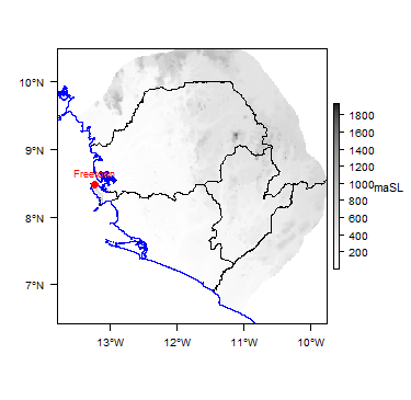
General
| Capital city | Freetown |
| Region | Western Africa |
| Border countries | Guinea, Liberia |
| Total surface area* | km2 (19,671,000 ha) |
| Total population (2015)* | 15,129,000 |
| Rural population (2015)* | 8,585,000 (56%) |
| Urban population (2015)* | 6,544,000 (44%) |
| UN Human Development Index (HDI) [highest = 1] (2014)* | 0.4659 |
* Source: FAO Aquastat
Climate
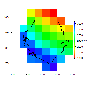
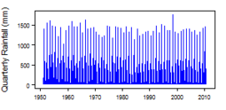
Sierra Leone has a humid tropical climate. Average annual rainfall is approximately twice the average annual potential evapotranspiration. Rainfall is highly seasonal, with a peak in August and a dry season from December to March. Inter-annual variation in rainfall is generally small, but there are some extreme rainfall events.
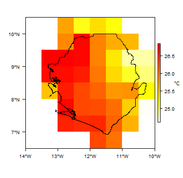
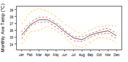
Temperatures are relatively uniform throughout the year, ranging from 24 to 28 degrees C. Lowest temperatures are from July to September, in the middle of the rainy season, and highest temperatures are in February and March, near the in end of the dry season (Lapworth et al. 2015).
More information on average rainfall and temperature for each of the climate zones in Sierra Leone can be seen at the Sierra Leone climate page.
These maps and graphs were developed from the CRU TS 3.21 dataset produced by the Climatic Research Unit at the University of East Anglia, UK. For more information see the climate resource page.
Surface water
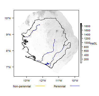
Five main rivers flow from northeast to southwest across Sierra Leone: the Little Scarcies, Rokel, Jong, Sewa and Moa rivers. Between them, they drain most of the land surface of the country. In addition, there are six smaller drainage basins: the Great Scarcies, Lokko, Rokel Estuary, Western, Robbi/Thauka and Sherbro Water Resources Areas. River runoff is highly seasonal, reflecting the seasonal distribution of rainfall. In the Rokel river, discharge increases from May, peaks in September and decreases to near-zero by March (Lapworth et al. 2015).
The Salone Water Security website includes data on surface waters in Sierra Leone, including maps of river basins and some monitoring data on surface water flows and levels.
|
|
 |
Soil
There is extensively weathered tropical soil, including distinctive duricrust development. The lowland area in the west of Sierra Leone is dominated by strongly weathered ferrasols with low nutrient levels. The upland area in the east has a partial cover of pisoplinthic plinthosols - soils with accumulations of iron that harden irreversibly when exposed to air and sunlight. Toward the coast these become yellow in colour. Elsewhere there are lithic leptosols - shallow soils over hard rock with bedrock close to the surface. In many cases, iron rich tropical soils contain openings and macropores which permit rapid infiltration and flow of water (Lapworth et al. 2015).
 |
Land cover
 |
Water statistics
| 2002 | 2014 | 2015 | |
| Rural population with access to safe drinking water (%) | 67.3 | ||
| Urban population with access to safe drinking water (%) | 92.9 | ||
| Population affected by water related disease | No data | No data | No data |
| Total internal renewable water resources (cubic metres/inhabitant/year) | 1,705 | ||
| Total exploitable water resources (Million cubic metres/year) | No data | No data | No data |
| Freshwater withdrawal as % of total renewable water resources | 5.699 | ||
| Total renewable groundwater (Million cubic metres/year) | 25,000 | ||
| Exploitable: Regular renewable groundwater (Million cubic metres/year) | No data | No data | No data |
| Groundwater produced internally (Million cubic metres/year) | 3,500 | ||
| Fresh groundwater withdrawal (primary and secondary) (Million cubic metres/year) | No data | No data | No data |
| Groundwater: entering the country (total) (Million cubic metres/year) | No data | No data | No data |
| Groundwater: leaving the country to other countries (total) (Million cubic metres/year) | No data | No data | No data |
| Industrial water withdrawal (all water sources) (Million cubic metres/year) | 58 | ||
| Municipal water withdrawal (all water sources) (Million cubic metres/year) | 98 | ||
| Agricultural water withdrawal (all water sources) (Million cubic metres/year) | 2,065 | ||
| Irrigation water withdrawal (all water sources) 1 (Million cubic metres/year) | No data | No data | No data |
| Irrigation water requirement (all water sources) 1 (Million cubic metres/year) | 949.4 | ||
| Area of permanent crops (ha) | 68,000 | ||
| Cultivated land (arable and permanent crops) (ha) | 3,268,000 | ||
| Total area of country cultivated (%) | 16.61 | ||
| Area equipped for irrigation by groundwater (ha) | 10,000 | ||
| Area equipped for irrigation by mixed surface water and groundwater (ha) | No data | No data | No data |
These statistics are sourced from FAO Aquastat. They are the most recent available information in the Aquastat database. More information on the derivation and interpretation of these statistics can be seen on the FAO Aquastat website.
Further water and related statistics can be accessed at the Aquastat Main Database.
1 More information on irrigation water use and requirement statistics
Geology
The geology map here shows a simplified overview of the geology at a national scale (see the Geology resource page for more details).
Download a GIS shapefile of the Sierra Leone geology and hydrogeology map.
A more detailed national geological map at 1:250,000 scale was compiled in 2004 by the Council for Geosciences for the Geological Survey of Sierra Leone (CGS 2004) - contact the National Minerals Agency for more information. Further information may be available in the report UN (1988).
Summary
Most of Sierra Leone is underlain by Precambrian cratonic rocks of the Archaean Basement Complex (Lapworth et al. 2015). A major belt of late Precambrian (Upper Proterozoic) to Lower Palaeozoic age metasedimentary rocks, with some (meta)volcanic rocks, occurs in the western part of the country (Camus and Cukor 2012, Lapworth et al. 2015). These are often capped by a weathered zone of unconsolidated material, where the Precambrian basement rocks have been weathered in-situ to sand, gravel and clay. They are also often capped by a layer of laterite or ferricrete.
There are outcrops of intrusive igneous rocks across the country, which are generally of granitic composition (Camus and Cukor 2012, Lapworth et al. 2015).
Across the country, river valleys often contain infills of unconsolidated alluvial deposits, laid down by rivers. Along the coastal belt there are also extensive outcrops of coastal, marine and estuarine unconsolidated deposits.

| Key Formations | Period | Description | |
| Unconsolidated sediments | |||
|---|---|---|---|
| Bullem Group | Tertiary to Quaternary | Poorly consolidated marine and estuarine sediments, largely sands, gravels and kaolinitic clays with some lignite (Lapworth et al. 2015). | |
| Igneous intrusive | |||
| Freetown Peninsula Complex and other intrusions | Mostly Mesozoic | ||
| Consolidated (meta)sedimentary rocks; some volcanic rocks | |||
| Saionya Scarp and Rokel River groups | Upper Proterozoic to Lower Palaeozoic | Shales, schists, metaconglomerates and quartzites, metacherts and banded iron formations (BIF), with volcanic bands (Camus and Cukor 2012, Lapworth et al. 2015). | |
| Basement Complex | |||
| Marampa and Kasila groups | Precambrian (Archaean) | Crystalline granitic gneisses with supracrustal metamorphosed volcanic and sedimentary belts. The Marampa Group is dominated by metasedimentary and volcanic rocks; the Kasila Group is dominated by granulites, basement granites, gneisses and migmatites, volcanic greenstone, amphibolite and gneiss. The granitic basement has a well-developed fracture network (Lapworth et al. 2015). | |
Hydrogeology
The hydrogeology map below shows a simplified overview of the type and productivity of the main aquifers at a national scale (see the Hydrogeology map resource page for more details).
Download a GIS shapefile of the Sierra Leone geology and hydrogeology map.
A comprehensive report on the Hydrogeology of Sierra Leone was published in 2017.
Maps, data and more information on groundwater in Sierra Leone are also available through SALGRID - the Salone Groundwater Resources Database portal, the official data portal and repository of hydrogeological information of the Government of Sierra Leone.
Other sources with information on the hydrogeology of Sierra Leone are listed in the References section, below.

.

.
Summary
The main hydrogeological distinction in Sierra Leone is between the relatively low permeability and productivity aquifers formed by the crystalline Precambrian Basement Complex, consolidated metasedimentary rocks and igneous intrusions; and the higher permeability and storage of the Bullom Group unconsolidated sand aquifer in the coastal zone. The weathered basement rocks form the most widespread and important aquifer across most of Sierra Leone.
Unconsolidated Sedimentary
| Named Aquifers | General Description |
| Alluvial (valley fill) deposits | Sands, gravels and clays that overlying the basement rocks, usually up to 15 m thick. They can have high permeability. Groundwater storage and flow is entirely intergranular. There is little data on borehole yields, but it is likely that yields of between 0.3 and 5 litres/second (l/s) will be possible (Lapworth et al. 2015). |
| Bullom Group | Unconsolidated sands and clays (inland alluvial & coastal), usually 10 to 20 m thick, can form a moderately productive aquifer with potential borehole yields up to 3 l/s. Groundwater flow is intergranular and storage capacity can be high. Fracture flow is less common (Lapworth et al. 2015).
Below this are interbedded sands and clays which are typically 30 to 80 m thick. Boreholes can often abstract up 6 l/s (Lapworth et al. 2015). |
Consolidated (meta)Sedimentary - Fracture Flow
| Named Aquifers | General Description |
| Saionya Scarp / Rokel River groups | There is a near-surface weathered (regolith) layer that is often dominated by clay. Below this are ancient conosolidated (meta)sedimentary rocks, with very little intergranular porosity. Groundwater storage and flow occurs within fractures in the rock, which are often along old bedding plains, although there is little information on potential borehole yields (Lapworth et al. 2015). |
Igneous
| Named Aquifers | General Description |
| Granites, gabbros, dolerites | Fractured gabbros are thought not to typically develop a thick weathered zone. Groundwater is likely to flow through the igneous rocks largely in fractures, although thin weathered zones may also contribute. There is little information on borehole yields (Lapworth et al. 2015). |
Basement Complex
| Named Aquifers | General Description |
| There is typically a layer of highly weathered rock (regolith) overlying the unweathered bedrock, which has often transformed to a thick tropical soil. This is generally up to 20 m thick, although up to 37 m thick has been seen. The upper section of this weathered zone often has relatively little clay - the clay minerals have often been leached out, leaving metal oxides. These metal oxides are often in the form of indurated or gravelly layers, which can be highly permeable, and can allow rapid horizontal groundwater flow. Towards the bottom of the weathered zone, the weathered rock is often dominated by clays, and therefore has much lower permeability. Yields from shallow boreholes abstracting from this zone are typically in the range 0.3 to 1.5 l/s. This shallow aquifer tends to dry up rapidly when the rains stop and groundwater drains rapidly away through the permeable material. It is vulnerable to contamination, because of limited attenuation potential in the subsurface and rapid horizontal and vertical groundwater flow pathways for seasonal rainfall recharge (Lapworth et al. 2015).
At the base of the weathered zone, the underlying crystalline bedrock is often extensively fractured and not clay rich, and can store and transmit groundwater through fractures. There can also be deeper fracture zones associated with faults. The average thickness of the fractured aquifer zone is 35 m, but it can be as much as 60 m. Borehole yields are typically between 0.3 and 1.5 l/s. Groundwater flowpaths are usually longer than in the shallow weathered aquifer, and groundwater flow can be rapid over distances of tens of metres. This deeper, fractured aquifer zone is typically a more sustainable groundwater source than the upper weathered zone. It also has more potential for the natural attenuation of contaminants, because of the overlying clay zone and the longer flowpaths (Lapworth et al. 2015). |
Groundwater management
Information on groundwater sources (water points) is collected in certain districts, but there is no central national database of groundwater sources. Borehole logs with geological information are not readily available.
The National Water Resources Management Agency (NWRMA) was established in 2017 and started operations in 2019. Its mandate is to protect, manage and regulate surface and groundwater resources in Sierra Leone. The Agency (NWRMA) is responsible for granting of water rights, water resources allotment among competing users, formulation of regulatory measures, information/data collection and sharing on water resources, with a view also to controlling pollution. Transboundary water resource issues also fall under the mandate of the Agency.
The Hydrological Services Department within the NWRMA is responsible for collecting, processing and analysing hydrogeological and water quality data.
Before the NWRMA was established, the Sierra Leone Water Security Project, funded by the UK Department for International Development (DFID), had the overall aim of establishing the foundations for water security in Sierra Leone. The Salone Water Security project website used to provide data from the project, but as of 2021 this website appears to be defunct. A detailed report on water monitoring produced by the project is available from the NWRMA website, as well as other reports and studies related to water resources monitoring and management ((Ministry of Water Resources, 2015).
During the Water Security Project, a groundwater monitoring network was installed to measure groundwater levels, from November 2012 onwards. Monitoring of this network was not continued after the end of the project, but the NWRMA now provides groundwater level monitoring data collected during the project. Future groundwater level monitoring data may be available from here. The NWRMA has a map showing a proposed national groundwater monitoring network, overlaid on a simplified geological map, which is also shown in Ministry of Water (2015).
Transboundary aquifers
For further information about transboundary aquifers, please see the Transboundary aquifers resources page
References
The following provide more information on the geology and hydrogeology of Sierra Leone. Some of these, and many other documents, can be accessed through the Africa Groundwater Literature Archive
Camus Y and Cukor D. 2012. NI 43-101 Technical Report on the Resource Update Nimini Gold Project, Kono Region, Sierra Leone. SGS Canada Inc., submitted to Polo Resources Ltd.
CGS. 2004. Geological Map of Sierra Leone. Contact National Minerals Agency for details.
Fileccia A, Teatini P, Walther C and Mastrocola P. 2017. Hydrogeology of Sierra Leone. Ministry of Water Resources, Freetown, Sierra Leone.
Flinch JF, Huedo JL, Verzi H, Gonzalez H, Gerster R, Mansaray AK, Painuly LP, Rodriguez-Blanco L, Herra A, Brisson I and Gerard J. 2009. The Sierra Leone-Liberia Emerging Deepwater Province. Adapted from oral presentation at AAPG Annual Convention, Denver, Colorado, June 7-10, 2009.
Goodenough KM, Jones D and Ford J. 2018. Geological mapping of Sierra Leone : baseline assessment and next steps. British Geological Survey Open Report OR/18/004.
Lapworth DJ, Carter RC, Pedley, S and MacDonald AM. 2015. Threats to groundwater supplies from contamination in Sierra Leone, with special reference to Ebola care facilities. British Geological Survey Technical Report OR/15/009, Nottingham, UK, 87pp.
Ministry of Water Resources. 2015. Water resources monitoring in Sierra Leone: The 'why' and how' of water resources monitoring. Republic of Sierra Leone. Volume 2 of a three-volume set, March 2015.
United Nations. 1988. Groundwater in North and West Africa: Sierra Leone. United Nations Department of Technical Cooperation for Development and Economic Commission for Africa. Department of Technical Cooperation for Development and Economic Commission for Africa, Natural Resources/Water Series No. 18.
Return to the index pages:
Africa Groundwater Atlas >> Hydrogeology by country

